Reconstruct complex underground structures with multi-source data fusion. Leverage comprehensive spatial intelligence of underground infrastructure, with precise dimensional data and structural conditions to support the entire asset lifecycle.
Application Scenarios
New Construction & Renovation: High-precision mapping enables evidence-based design and construction validation, ensuring structural integrity while reducing costly field modifications.
Structural Health Monitoring: Systematic scanning identifies emerging deficiencies (microfractures, deformation, and displacement) before they compromise safety, enabling preventative maintenance and extending service life.
Disaster Assessment & Emergency Response: Rapid post-event scanning provides actionable damage assessments following disasters, facilitating evidence-based recovery while minimizing downtime.
Asset Management & Operational Excellence: Digital twins support data-driven maintenance, space optimization, and risk mitigation strategies that enhance efficiency while reducing lifecycle costs.
Challenges Addressed
Upgrade field surveys that drain resources with lengthy timelines and costly paper-based workflows requiring manual processing.
Overcome equipment constraints and operator error that compromise accuracy, especially in complex environments where optimal survey positions are elusive.
Replace fragmented spatial intelligence that misses critical details and fails to represent actual site conditions.
Resolve poor reusability and reduce resurveying costs that create stale data environments that cannot support timely decision-making.
The XGRIDS Advantage
Efficiency
Achieve 5 to 8 times faster data collection with a portable, single-operator system, even in complex environments.
Ease of Use
Capture real-time, true-color point clouds with “what you see is what you get” accuracy, powered by advanced Multi-SLAM for precise point cloud colorization.
Quick Data Processing
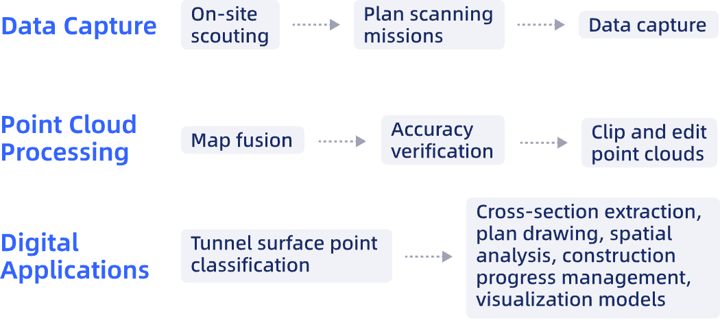
Efficient data processing through map fusion and concurrent dataset processing, yielding quick maps/profiles and easy AutoCAD integration via RCP export.
Actionable 3D Data
Integrate and reuse rich 3D models with clear textures and accurate real-world representation.
Hardware
Lixel L Series
High-Precision 3D Scanner
Lixel K Series
Compact 3D Scanner
Software
LixelStudio
Point Cloud Studio
Lixel CyberColor
Next-Gen 3D Content Format
Workflow
Case Studies
Mapping the City's "Lifeline": Lixel L2 Pro Assists in Surveying a 8km Underground Pipe Corridor
Breaking Depth Records: XGRIDS' Lixel L2 Revolutionizes 3D Scanning for the World’s Longest Undersea Highway Tunnel
Exploring Depths: Lixel L1 Unveils the Sublime Wonders of Tulumtaş Cave Through 3D Scanning