Convert existing buildings into structured BIM models with 3D Gaussian technology. Capture precise site conditions to accelerate digital transformation.
Application Scenarios
Virtual Training: Scan real environments like factories and transportation hubs. Create simulation-ready models that improve training outcomes and safety.
AR/VR Positioning: Capture indoor/outdoor environments with precision. Provide high-definition reference models for AR/VR applications that enhance user immersion.
Facility Management: Monitor building conditions in real-time. Create digital twins that alert property managers to maintenance needs before they become costly problems.
Historic Property Documentation: Preserve architectural details of heritage buildings digitally. Create permanent records for restoration projects and insurance documentation.
Challenges Addressed
Low Efficiency: Stationary laser scanners require multiple setups and extensive lighting. Eliminate time-consuming data collection and processing delays.
Limited Accuracy: Replace error-prone manual measurements and documentation with consistent digital processing for superior accuracy.
Environmental Limitations: Scan hard-to-reach areas like mechanical spaces and structural elements. Create complete documentation without disrupting tenants or operations.
The XGRIDS Advantage
Efficiency
Achieve 5 times faster data collection with a portable, single-operator system, even in complex environments.
High-Quality Reality Modeling
Generate Revit-compatible BIM models using integrated Multi-SLAM technology. Eliminate the modeling gap between point clouds and usable BIM elements.
Intelligent Component Recognition
Transform point clouds into parametric BIM components automatically. Detect structural elements, MEP systems, and architectural features.
Enhanced BIM Verification
Compare point cloud data against BIM models in real-time. Identify construction deviations instantly and update digital twins to reflect actual conditions.
Hardware
Lixel L Series
High-Precision 3D Scanner
Lixel K Series
Compact 3D Scanner
Software
Lixel CyberColor
Next-Gen 3D Content Format
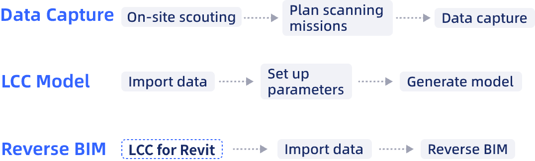
Workflow
Case Studies
LixelStudio v3.6 Release: Mastering Urban Canyons with Engineering-Grade Accuracy.
Efficient Scan-to-BIM with XGRIDS Solution: A Full-Workflow Case Study of an Electric Factory
The Virtual Job Site: Skender's Workflow for Measurable, Photorealistic Construction Documentation