Capture complete forestry data efficiently with high-precision 3D digital forest models. Enhance ecological resource investigation and management.
Application Scenarios
Forest Resource Management: Precisely measure tree density, height, and volume to create an accurate forest map. Convert traditional manual surveys into digital forest inventories with unprecedented detail.
Forest Health Monitoring: Track disease spread and pest infestations effectively. Identify stressed vegetation earlier with comprehensive monitoring.
Carbon Sequestration Assessment: Quantify biomass and carbon storage accurately. Support carbon credit verification with data-driven forest measurements.
Wildfire Risk Mapping: Identify high-risk areas with detailed fuel load mapping. Create evacuation plans with complete terrain understanding.
Conservation Planning: Map biodiversity hotspots with precision. Monitor protected habitats with minimal ecological disruption.
Accuracy Barriers: Eliminate errors caused by difficult terrain and manual tools. Capture precise data with a walk in the forest.
Data Gaps: Resolve incomplete data collection caused by manual sampling. Gain both individual tree metrics and forest data with a simple workflow.
Outdated Inventory: Detect disease outbreaks, illegal harvesting, and growth patterns as they occur, not months afterward.
The XGRIDS Advantage
Efficiency
Achieve 5 to 8 times faster data collection with a portable, single-operator system, even in complex environments.
Ease of Use
Capture real-time, true-color point clouds with “what you see is what you get” accuracy, powered by advanced Multi-SLAM for precise point cloud colorization.
Quick Data Processing
Enable rapid forestry analysis by streamlining data processing with map fusion and concurrent processing for fast, detailed tree-level maps.
Actionable 3D Data
Integrate and reuse rich 3D models with clear textures and accurate real-world representation.
Hardware
Lixel L Series
High-Precision 3D Scanner
Lixel K Series
Compact 3D Scanner
Software
LixelStudio
Point Cloud Studio
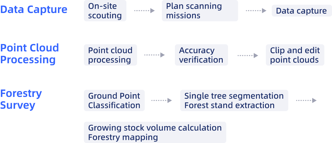
Workflow
Case Studies
50% Accelerated Full-Project Lifecycle Infrastructure QA Using XGRIDS LiDAR + 3DGS Solution - AECT SOLUTIONS in Australia