Transform water infrastructure monitoring with real-time 3D data capture and precise 3D models, enhancing safety and decision-making.
Application Scenarios
Infrastructure Management: Create precise digital twins for dams, reservoirs, and flood control structures. Track structural changes over months and years with centimeter precision, enabling proactive maintenance and preventing costly failures.
Engineering Assessment: Capture comprehensive structural data that reveals hidden deformation patterns and erosion progression. Gain actionable insights from visual timelines showing how conditions evolve under varying water levels and seasonal changes.
Emergency Response: Rapidly collect critical data during floods or dam compromises. Instantly measure harbor positions, volumes, and affected areas to coordinate rescue resources and develop containment strategies with precision.
Challenges Addressed
Replace unreliable inspections of hazardous structures with consistent digital documentation.
Eliminate information gaps between inspections with historical comparisons showing progressive changes.
Remove personnel from dangerous environments while gathering more precise data.
Unify fragmented data into comprehensive 3D models accessible to all stakeholders.
The XGRIDS Advantage
Precision
Lixel L2Pro/K1 devices capture centimeter-accurate details of harbor entrances and dams, revealing soil erosion and structural cracks. Automatically get area and volume measurements using centimeter-grade 3D models.
Proactive Risk Monitoring
Reduced need for personnel in hazardous environments.
Complete Digital Documentation
Create 3D archives of dam surfaces, precisely recording cracks and seepage points with full data integrity across time.
Hardware
凌巡S系列
多源感知应急测绘机载设备
实时建模,广域覆盖,精准识别
Lixel L Series
High-Precision 3D Scanner
Lixel K Series
Compact 3D Scanner
Software
LixelStudio
Point Cloud Studio
Lixel CyberColor
Next-Gen 3D Content Format
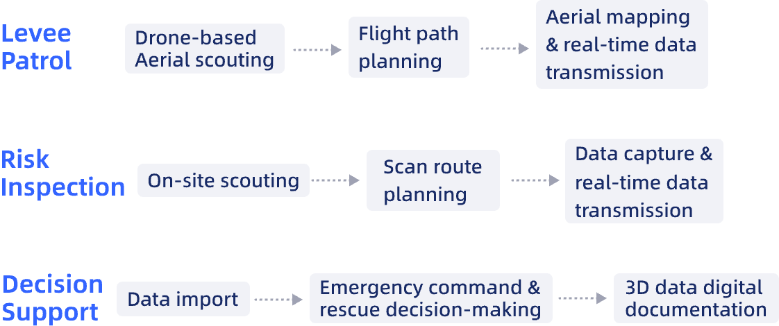
Workflow
Case Studies
Engineering-Grade Point Clouds: What the Term Means, Why It Matters, and What It Takes
Mobile LiDAR for Underground Stope Monitoring: XGRIDS Lixel L2 Pro in Chilean Mining