Capture precise volumetric data using LiDAR across diverse materials to support material management and cost verification throughout project cycles.
Application Scenarios
Resource Planning: Acquire accurate stockpile measurements for mining and earthworks to establish reliable resource estimates and planning baselines.
Environmental Compliance Monitor volume changes in waste stockpiles to generate critical data for pollution control and remediation efforts.
Logistics Optimization Measure bulk material quantities to optimize warehouse space utilization and improve material transport efficiency.
Disaster Response Assess volumetric changes rapidly after natural events (mudslides, landslides) to provide essential data for emergency response.
Challenges Addressed
Manual Inefficiency: Overcome traditional survey methods requiring excessive labor while limiting measurement points and comprehensive representation.
Accuracy Barriers: Address precision limitations from measurement distances and complex geometries preventing accurate three-dimensional data capture.
Processing Complexity: Eliminate time-intensive calculations prone to errors, especially with complex stockpile shapes and increasing measurement points.
Safety Limitations: Resolve proximity measurement risks and extended data collection cycles that delay critical operational decisions.
The XGRIDS Advantage
Efficiency
Boost productivity 5 to 10 times through contactless measurements that enhance safety while enabling single-operator capture of complex stockpile environments.
Ease of Use
Capture real-time, true-color point cloud data with “what you see is what you get” accuracy, powered by advanced Multi-SLAM for precise point cloud colorization.
Quick Data Processing
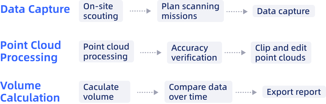
Complete volume calculations in just three steps with automated reporting and multi-period comparison capabilities for tracking inventory changes over time.
Hardware
Lixel L Series
High-Precision 3D Scanner
Lixel K Series
Compact 3D Scanner
Software
LixelStudio
Point Cloud Studio
Workflow
Case Studies
Earthwork Volume Calculation with XGRIDS L2 Pro — 2,000m² Construction Site Survey, Turkey
Revolutionize Stockpile Measurement for Lithium Mica Piles by Lixel Scanning System